Nomansland Common
Open all year
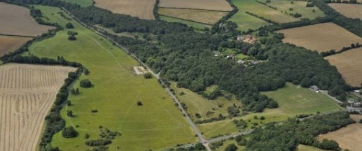
52 ha of heathland, wildflower meadows and woods between St Albans and Wheathamstead. 1 route and 7 points of interest
Glade
Woodland
Sunny woodland paths and glades are also important for butterflies and other insects, and the birds that feed on them.
Heathland and Dry Valley
Meadow
The Common is a haven for wildlife and the healthland to the north of Ferrers Lane is some of the best in south Hertfordshire, supporting a wealth of rare plants and animals.
In the past Nomansland Common was grazed by sheep which maintained the Commons open character but in the last seventy years grazing has ceased and the amount of woodland has increased. Without management the Common would become completely wooded. The remaining areas of open heath are heavily grazed by rabbits, which are controlled and areas of heath are fenced temporaily so heathland plants can grow.
To the south of Ferrers Lane the large open grassland is cut for hay each year in the autumn.
Oak Trees and Woodland
Woodland
In many areas of the Common, the low scrub has given way to woodland of Oak and Birch Trees, some of which may be at least 100 years old.
As the trees age and decay they can support more wildlife. Cracks in the bark and holes caused by rot are great for hibernating bats, specialist fungi and rare insects.
Woodland
Woodland
The woodland areas on the edge of the heath are thinned by removing selected trees to give stronger specimens more room to grow.
Veteran trees have their crowns and limbs cut back which makes them more stable and can prolong their lives.
Woodland paths are also cut back to allow more light and air to reach the ground, this creates sunny glades for wildlife and helps prevent the paths becoming too muddy
Park Information
Nomansland Common is a very popular recreational area for dog walkers, horse riders, flying kites & model airplanes, and families who enjoy a picnic on a Sunday afternoon. The Common is also a haven for wildlife and the heathland on the north side of Ferrers Lane is some of the best in South Hertfordshire and continues to support a wealth of rare plants, including Dwarf Gorse and Heather.
Nomansland Common is an area of 52 hectares of open space, owned by the Althorp estate and Wheathampstead Parish Council.
Common land or wastes in a parish, were often uncultivated and of little agricultural value, but were owned by the local Lord. In times gone by villagers or ‘commoners’ relied on commons for their livelihoods. The commoners would have ‘common rights’ to graze livestock and gather firewood, and were fiercely protective of their rights against unscrupulous Lords who might try to enclose the land for their own private farms. In many areas you can still see hollows where commoners dug clay for brick making and evidence of brick kilns have been found.
Nomansland Common lies across two parishes, Sandridge and Wheathampstead. During the 15th Century the monasteries of St Albans and Westminster both contested the Common for their respective parish and acted as the ‘no-mans-land’ between the two warring factions, with over twenty years of disputes. Finally in 1429, a jury agreed that the parishes should share the grazing rights and a boulder of Hertfordshire pudding stone was used to mark the parish boundary.
Humans have used Nomansland Common for thousands of years and flint axe heads found on the Common have been dated to 4,000BC.
Since at least the Middle Ages, commoners have used Nomansland to graze their livestock and within living memory three flocks of sheep were grazed on the Common.
In 1461, during the Wars of the Roses, the Yorkist army retreated across the Common during the Second Battle of St Albans, which may be an explanation for the cannon balls and 25 skeletons supposedly found on the Common in the 19th century.
During the 1700’s Nomansland was a notorious place for highway robberies, so much so that a gibbet was erected on the Common as a warning to would be thieves.
The most notorious robber of the time was dubbed the Wicked Lady, she was unmasked after her death as Lady Ferrers of Markyate.
Although the Common fell into private ownership in the 17th century, the local population retained the grazing rights. The Common has long been used for sports and leisure activities. In the 18th century hunting was popular, while in 1826 cricket was introduced.
The Common also became a venue for brutal prize fighting, sometimes with fatal consequences, In 1833 a fight between Simon Byrne champion of Ireland and James Burke lasted 99 rounds (about 3 hours). Horse racing also took place between 1829 and 1837 which was supported by nobility. In 1829 George IV won the St Albans Cup on the course. Since the heydays of formal sports on the Common, the area has provided a location for more passive recreational activities.
During WW II Field Marshal Montgomery reviewed some of his troops here prior to making an assault on the Second Front and German & Italian prisoners of war cleared scrub on the southern half of the common, so it could be ploughed for crops to help the war effort. In 1965 the Common was registered under the Commons Registration Act. The area is unified by its historical origin as an unenclosed open margined Common (The Landscape Partnership 2001).
On Site Facilities
- Car Park (Free)

- Dogs Welcome

- Pushchair Friendly Paths

How to get here
Parking:Car parking available on Ferrers Lane. Directions here
Nomansland Common is situated between the villages of Wheathampstead and Sandridge, approximately 2 miles north of St Albans, Hertfordshire.
Public Transport Information:The nearest station is 3 miles away in Harpenden (First Capital Commext from London, St Pancras) and the nearest bus stop is at the Wicket Lady Public House.
Further information on public transport is available here: https://www.intalink.org.uk/ and www.nationalrail.co.uk
Share your experience
Tell your friends on social media about what you did at Nomansland Common: